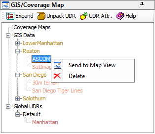
External GIS data must be
imported into TEMS Discovery. The imported GIS data will be listed in the GIS List, providing an overview of the GIS data that TEMS Discovery can access. The GIS data in this view can be sent to the
Map View for display.
When importing GIS data, you will be asked to define a geo area name for that data. In the GIS List, the GIS data will then be organized by its geo area. When you create a project, one of the geo areas listed in this window can be assigned to the
Geo Area property of the project. See
Project List for more information.
Global UDRs can be used to match drive test data against project/dataset when
importing drive test data to decide where (project and dataset) to put the imported log file if the user has selected the
Use global UDR specified project/dataset option.